Inner Banner
Inner Banner
Inner Banner

Solutions

Digital Agronomy

Digital Agronomy

Innovative agronomic tools that helps farmers see problems early and act faster.

Trusted on over 50,000 farms.

Trusted on over 50,000 farms.

A practical, easy-to-use, digital platform that helps you plan, monitor, and analyse your crops and pastures — no downloads, no complex setup, just log in and GROW.

65
65
65

Million hectares

Million hectares

330,000+
330,000+
330,000+

Paddocks/Fields

Paddocks/Fields

53,000+
53,000+
53,000+

Farms

Farms

Using military grade satellite imagery to detect weeds and turn your conventional boom into a spot sprayer.

Using military grade satellite imagery to detect weeds and turn your conventional boom into a spot sprayer.

Reducing herbicide use with satellite imagery.

Satellite data collection over fields

High-resolution satellite imagery is captured over cropping fields to monitor weed presence, Green on Brown (in fallow) currently available, with Green on Green in crop available soon.

High-resolution satellite imagery is captured over cropping fields to monitor weed presence, Green on Brown (in fallow) currently available, with Green on Green in crop available soon.

Weeds detected and buffered

Advanced algorithms analyze the satellite data no detect and map the precise locations of weed infestations within the fields.

Advanced algorithms analyze the satellite data no detect and map the precise locations of weed infestations within the fields.

Sprayer treats only weed impacted areas

Sprayers apply herbicides specifically to the weed-affected zones, minimising chemical usage and reserving healthy crops. Any boom sprayer with section or nozzle control is likely to be compatible.

Sprayers apply herbicides specifically to the weed-affected zones, minimising chemical usage and reserving healthy crops. Any boom sprayer with section or nozzle control is likely to be compatible.

Detect weeds using our specialised algorithms

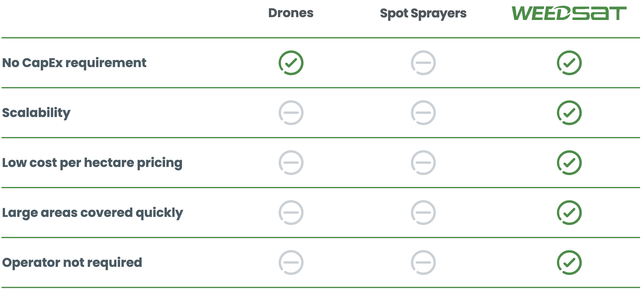
WeedSAT™ uses military grade satellite imagery to detect weeds using custom algorithms. Buffers around the weed and export to a file, ready for the sprayer to treat only weed-impacted areas.


WeedSAT is one of several technologies developed with investment from the Grains Research and Development Corporation (GRDC) through the Grain Automate project. Grain Automate is an initiative on behalf of Australian grain growers aimed at accelerating the adoption of machine automation, autonomy and digital technologies in the Australian grains industry. R&D investment in this technology does not indicate commercial product endorsement by GRDC. We also acknowledge the support of the University of Sydney in algorithm development.

Green on Brown
Green on Brown

Weeds in fallows (gap between crops)

Green on Green
Green on Green

Weeds whilst the crop is growing

Cost effective
Cost effective

1/6th (or less) of the control cost

Reduce Herbicide Use

~70-80% reduction in herbicide use

RapidEM™ – soil mapping tool.

RapidEM™ – soil mapping tool.

A smarter, faster way to understand your soil — now available for on-farm use.

A smarter, faster way to understand your soil — now available for on-farm use.

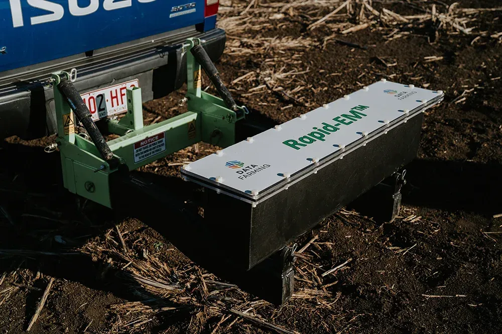
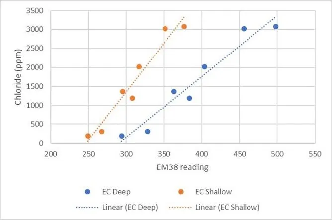
RapidEM™ is an autonomous soil electrical conductivity mapping solution that provides detailed information about soil type and soil properties to enable variable rate (VR) soil improvement applications.

EM measures soil types using a non-contact machine which measures 0.50m and 1.2m down into the soil profile. When combined with soil test data, we obtain a holistic picture of soil factors such as salts, water, and clay content.


The unit easily installs behind vehicles (in the towball hitch) and automatically logs data when moving around your paddocks. A key feature is that the RapidEM™ sends the data to the ‘cloud’, avoiding the need to shift data manually using USB’s, etc. The data is currently processed and available in our online platform. 

RapidEM™ will be a great tool for agronomists who can now offer EM data collection and processing services.

Hiring the unit means agronomists don’t need capital outlay to get mapping, just a ute and willing customers. Farmers can hire the unit for $5/ha+GST with a minimum charge of $1200+GST per use.

Hiring the unit means agronomists don’t need capital outlay to get mapping, just a ute and willing customers. Farmers can hire the unit for $5/ha+GST with a minimum charge of $1200+GST per use.

For more information go to https://www.datafarming.com/

For more information go to https://www.datafarming.com/

For more information go to https://www.datafarming.com/

Ready to Turn Your Data into Value?

We consolidate your farm’s data into one reliable version of the truth — unlocking operational clarity and financial opportunity. Start your digital journey with us today.

Ready to Turn Your Data into Value?

We consolidate your farm’s data into one reliable version of the truth — unlocking operational clarity and financial opportunity. Start your digital journey with us today.

Ready to Turn Your Data into Value?

We consolidate your farm’s data into one reliable version of the truth — unlocking operational clarity and financial opportunity. Start your digital journey with us today.